
Opelika ZIP Directory Coverage
Four ZIP codes are associated with Opelika, but they do not all mean the same thing. Opelika codes 36801 and 36804 have residential Census ZCTA counterparts. Opelika codes 36802 and 36803 are non-geographic routes for Opelika post office boxes or Opelika government mail. Postal Opelika also reaches beyond incorporated Opelika, especially to the south and east. The Opelika ZIP code directory must keep those distinctions visible before a name or parcel is assigned to a place.
| ZIP | Area served | Postal base | Key limit |
|---|---|---|---|
| 36801 | Central and northern Opelika civic core | 500 S. 7th Street Opelika facility | Residential ZCTA; city line differs |
| 36802 | Post office boxes | Main postal operation | No residential ZCTA polygon |
| 36803 | Opelika government and other box mail | Main postal operation | Not a residential neighborhood |
| 36804 | South and east Opelika delivery plus broad Opelika rural areas | Grouped with the Opelika scheme | Residential ZCTA extends well beyond city limits |
This Opelika division makes 36803 the clearest warning. An Opelika city or county office may use that ZIP for correspondence while its Opelika public counter stands in 36801. The mailing code does not move the physical Opelika office. Likewise, 36804 can be correct mail for an Opelika Lee Road property outside incorporated Opelika.
Reading Opelika ZIP 36801
Opelika ZIP 36801 is the best postal starting point for the Opelika civic core because the Lee County courthouse, the Opelika City Hall area, and Opelika's principal retail postal facility are in or associated with it. Yet an Opelika 36801 mailing label is not proof that a parcel sits inside Opelika city limits. For permits, municipal services, wards, or Opelika city court jurisdiction, open the city-limit layer and compare the Lee County CAMA tax District field.
The official USPS Opelika Post Office page identifies the facility at 500 South 7th Street, 334-745-3561. The Opelika facility's listed retail hours are Monday through Friday from 8:30 a.m. to 5 p.m. and Saturday from 9 a.m. to noon.
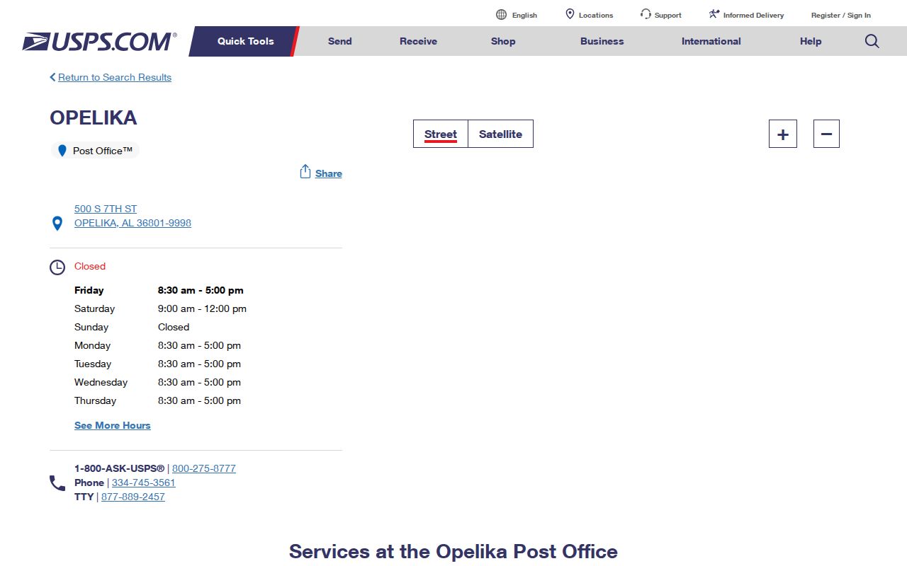
The Opelika capture confirms the Opelika public facility and its Opelika customer hours. Those hours describe counter access only; they do not define the Opelika 36801 delivery boundary.
Note: An Opelika post office address can confirm where Opelika mail services are offered, but it cannot establish whether a parcel is incorporated in Opelika.
Opelika Box ZIP Codes
Opelika codes 36802 and 36803 are routing codes for boxes, not shaded residential areas. Census does not treat them as Opelika residential ZCTAs, and neither should be used to build an Opelika neighborhood list. Opelika government correspondence is a common source of confusion because an Opelika official document may show 36803 while the Opelika agency's public counter has a 36801 street location.
For Opelika genealogy or record research, preserve the Opelika box code as mailing evidence. Then locate the situs address, meaning the Opelika physical place, through the Opelika document, Opelika property roll, or parcel map. A historic application or directory line with 36803 may identify where mail went. It does not identify the building, ward, block, or city-limit status on its own.
The exact box range and station assignment were not verified in the source set. That gap should remain open rather than being filled from a third-party ZIP list.
Opelika ZIP 36804 Beyond Town
ZIP 36804 is the central geography issue in the Opelika ZIP code directory. It serves southern and eastern Opelika delivery areas and broad rural or unincorporated parts of Lee County. Spring Villa's Lee Road address is an official example of an Opelika mailing location in this wider landscape. The words “Opelika 36804” therefore cannot establish city permit authority, municipal court jurisdiction, a ward, or city services.
Start with the Lee County CAMA property search. Search the physical street and number, then inspect the District and parcel fields. Follow with the Opelika municipal GIS layers for the city line. County road syntax also matters: Flagship expects a four-digit road number and “Rd” without a period, such as “Lee Rd 0023.”
The result is a verified chain: mailing label identifies postal routing, the CAMA parcel identifies the assessed site, and the municipal layer answers incorporation. If the address lies outside city limits, county records remain relevant while a search limited to city permits may fail for the correct reason.
Search Opelika Residents by ZIP
No verified Opelika public portal offers a true ZIP-wide resident browse. CAMA can display an owner mailing ZIP in results, but its public search form has no confirmed ZIP field. VoterView requires a person's first name, last name, date of birth, and CAPTCHA. It cannot enumerate a ZIP. Census ZCTA profiles provide counts and characteristics, never names. A useful ZIP search must work from a narrower known fact.
- Confirm a particular postal address with USPS. Record the standardized address, but do not infer the city line from the postal city.
- Search CAMA with the physical street number and street name. Use District=Opelika only when incorporated-city results are needed.
- Open the parcel in county or city GIS. Compare city limits, ward, subdivision, and other map layers that answer the actual question.
- For aggregate research, use the Census 36801 or 36804 ZCTA profile. Keep those statistical areas separate from USPS routes.
- For a lawful voter-data request, ask the Alabama Secretary of State for a narrow city, county, or district extract with selected residence fields. Do not claim that the form provides a ZIP-scope checkbox.
Once a physical road is known, the Opelika street directory provides the address-level workflow. ZIP narrows the postal context; street and parcel records do the local identification work.
Opelika ZIP Search Substitutes
Because the local property portal lacks a confirmed ZIP filter, its verified location fields should be shown as substitutes rather than relabeled. The Lee CAMA form can narrow an Opelika search by physical address, street, tax District, subdivision, acreage, or value. Results may show an owner mailing ZIP, but that output is correspondence data and may differ from the parcel's situs.
| Verified field | Input | Best geographic use | ZIP caution |
|---|---|---|---|
| PhyAddr # | Up to five characters | One physical street number | Not a mailing filter |
| St Name | Contains text, up to 20 characters | One street or road | Use Lee Road format where needed |
| District | Dropdown | Opelika tax jurisdiction | More useful than postal city |
| Subdivsn | Local dropdown | Platted development | May cross postal logic |
| Owner | Begins with or contains | Known assessed owner | Owner address may be elsewhere |
Searches return up to 1,000 rows and may be mapped or exported. If a broad county query reaches the cap, narrow by District, street, or subdivision. The roll is current-cycle assessment data and can lag a sale because Alabama property tax follows title as of October 1.
Opelika ZIP and City Boundaries
Opelika records geography has several layers. A parcel may use Opelika for mail, fall within Lee County for assessment and deeds, sit outside the municipal line, and have no city ward at all. Inside incorporated Opelika, ward and historic-district geography answer other questions. Carver, Jeter, Northside, Pepperell, and eastern growth areas cross simple postal assumptions, so their names should be checked against official map layers rather than assigned by ZIP alone.
Three address forms also describe different facts. A situs is the physical taxed location. A mailing address is where the owner or agency receives correspondence. A legal description identifies land by lot, block, subdivision, or metes and bounds. The legal description and parcel key are more stable than a ZIP when tracing older deeds or a parcel split.
- ZIP
- A USPS routing code for delivering mail, not a municipal boundary.
- ZIP+4
- A ZIP with four added digits that narrows a delivery segment, box group, or high-volume destination.
- PO-box ZIP
- A non-geographic code used to route mail to boxes rather than a residential polygon.
- Unique ZIP
- A code assigned to one high-volume organization; no such Opelika code was verified here.
- Carrier route
- A postal delivery path that can cross other government boundaries and is not a list of residents.
- ZCTA
- A Census statistical approximation of a residential ZIP area, used for aggregate data rather than mail delivery.
Opelika ZIP and Voter Records
The official Alabama VoterView is a self-check, not an Opelika ZIP directory. It requires first name, last name, date of birth, and CAPTCHA. A match confirms registration status, ballot status, and polling place with its address. It does not accept a ZIP-wide browse, and polling-place geography should not be treated as a list of everyone nearby.
A paid voter-file extract under Ala. Code §17-4-38 is a separate access channel. The request form supports county, city, or district scope; active, inactive, or both statuses; selected public residence and mailing fields; and an alternate sort. It does not publish a verified ZIP-scope checkbox. A requester can ask for a narrow Opelika or Lee County extract and a useful sort, then wait for a quote before paying. Participation data shows that a registrant took part, not how anyone voted.
Use the Secretary of State request form when that regulated extract is necessary. If the goal is one person's self-verification, use VoterView. If the goal is a property or boundary, return to CAMA and GIS. These channels answer different questions.
Historic Opelika Before ZIP Codes
Historical Opelika city directories and Sanborn maps predate ZIP codes. A 1923 directory address should be translated through its printed street name, house number, intersections, later maps, and parcel evidence. It should not be assigned 36801 or 36804 merely because that code serves the modern area. The same rule applies to the Sanborn editions from 1885 through 1909.
No verified local ZIP split date, realignment year, or postal-zone conversion was found. A family timeline should state that gap. For old addresses, the best bridge is the street itself: compare the directory's address-first section, a census, deeds, maps, and legal land identifiers. If a current parcel emerges, only then record its present postal code as modern context.
Postal geography also shifts less cleanly than jurisdiction. Lee County was created in 1866 from four parent counties, so records before that date may sit in older county indexes even though the place is now called Opelika. ZIP history cannot solve that records boundary.
Verify an Opelika ZIP Result
A reliable Opelika ZIP code directory result keeps the source and question together. USPS verifies standardized mail and facility service. Census describes the 36801 and 36804 ZCTAs in aggregate. Lee County CAMA ties a physical address to a parcel, assessed owner, District, and legal clues. The county and city GIS viewers show mapped context. VoterView confirms one registrant's own status, while the ordered file follows a separate statutory process.
When those sources disagree, do not force them into one boundary. Record the postal ZIP, situs address, tax District, city-limit status, ward if any, subdivision, and parcel key as distinct fields. That method handles the 36804 rural reach and the 36802 or 36803 box routes without turning mailing evidence into a resident claim.
For a city-held record that is not online, the Opelika NextRequest portal accepts focused municipal requests from Alabama residents. Name the address, record class, and date range. County property and deed records still belong with the Revenue Commissioner and Judge of Probate, not the City Clerk.